


Guest contribution from MeteoSwiss: Greetings from the desert: Saharan dust
Occasionally, desert dust from North Africa can be transported to our region. This week, the weather conditions are right again. Sahara dust is expected to remain in the air here until after the weekend. This poses a particular challenge for weather forecasting.
Photo above: Sahara dust event on June 28, 2019. View from Baldegg above Baden towards the northwest, with Geissberg approx. 12 km away on the right. Photo: Daniel Buck
How does Sahara dust affect the weather?
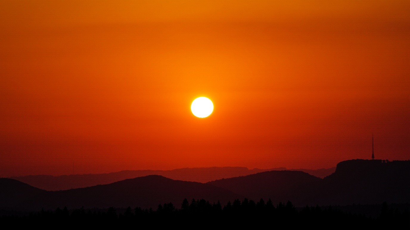
On the one hand, the dust in the air causes cloudiness with corresponding visibility restrictions, which is not ideal weather for a photo flight. In cloudless conditions, the sky no longer appears blue, but whitish to yellowish or even orange. If the airflow over Switzerland is weak and there is no precipitation, the Saharan dust remains in the air longer and settles into lower layers of air day by day before finally reaching the earth’s surface and becoming visible on garden furniture, window sills, and vehicles. The mineral sand particles even have a fertilizing effect on the soil.
Most weather models do not include Saharan dust events; they simply calculate a predefined amount of aerosols. However, the dust has a major impact on the weather: the additional condensation nuclei can lead to an increase in cloud cover. With a sufficiently high dust concentration and enough moisture, existing cloud fields become denser. In extreme cases, inconspicuous thin veil clouds can turn into an overcast sky. This presents us meteorologists with the great challenge of forecasting cloud cover with Sahara dust as accurately as possible and, if necessary, adjusting the temperatures. Automatically generated products such as local forecasts or model calculations then often turn out to be too sunny and calculate temperatures that are too high. Despite high-pressure weather, there could therefore be restrictions in sunshine, and not just due to morning fog. Below are the forecasts of the ICON-CH-2 model for the daily duration of sunshine this week, which does not reflect the influence of Saharan dust.
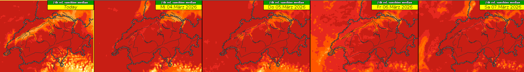 Daily sunshine duration from Tuesday (Today), March 3, to Saturday, March 7, 2026: The redder, the sunnier. The reduced solar radiation due to cumulus clouds in the south and morning fog in the Swiss Plateau is clearly visible, but hardly noticeable due to the cloud fields, which may be denser with Saharan dust on Thursday and especially on Friday. Graphic: MeteoSwiss
Clouds enriched with Saharan dust are often visible on satellite images: they show a typical ribbed surface structure. The turbulent surface is particularly visible in the morning hours because small-scale thermals form on the cloud surface with the Saharan dust.
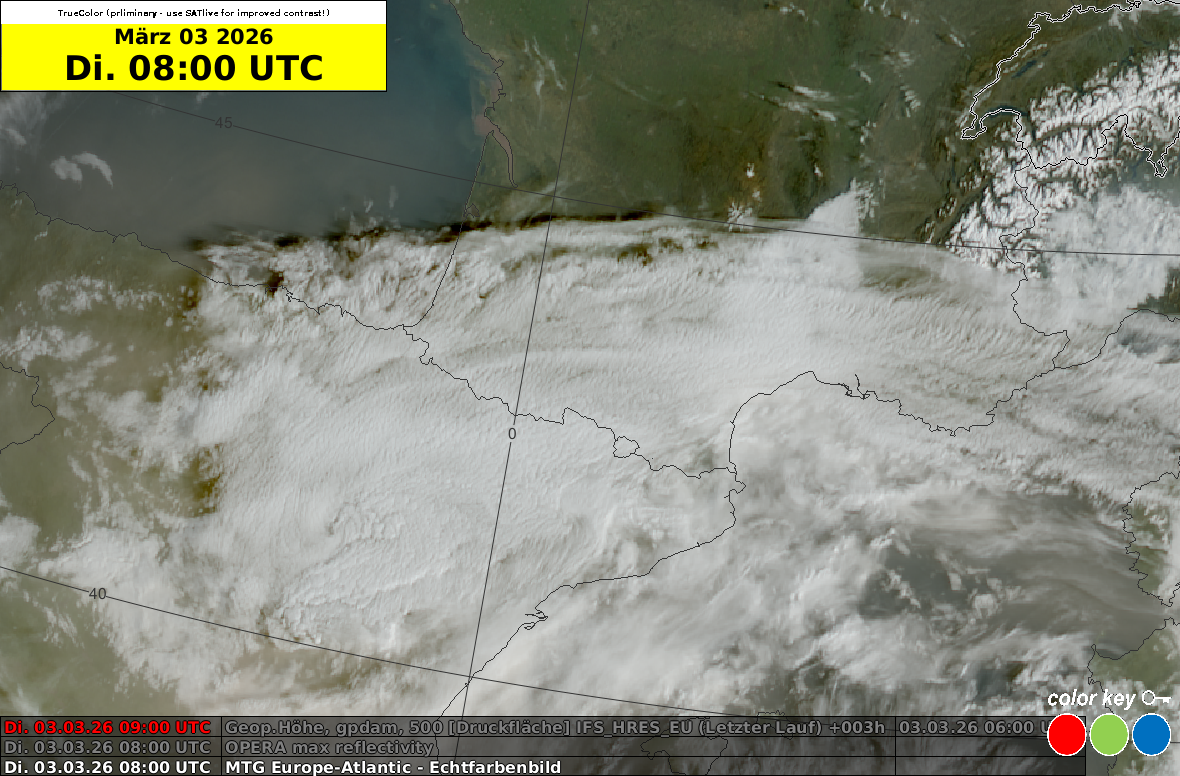
MTG satellite image (Meteosat Third Generation) from Tuesday, March 3, 8 UTC: At the beginning of the week, Saharan dust was carried over Spain to the Bay of Biscay. The brownish haze is clearly visible over the sea. The clouds over the Pyrenees show the ribbed pattern typical of Saharan dust. Source: Eumetsat
When is Saharan dust transported to Switzerland?
Various processes must interact to make this transport possible. First, there must be sufficient wind in the Sahara to whip the mineral dust from the ground into the air. This can be triggered by convection on the one hand, or by fronts on the other. Low-pressure areas with fronts are well suited for further transport to the Alpine region, because a southwesterly upper-level flow also sets in on the front side. At the beginning of the week, the powerful low-pressure system “Regina” moved from the Atlantic to Morocco and already led to dust transport in the western Mediterranean region. The following graphic shows the dust concentration in combination with the pressure conditions at altitude. These calculations are based on a model that specializes in dust in the atmosphere.
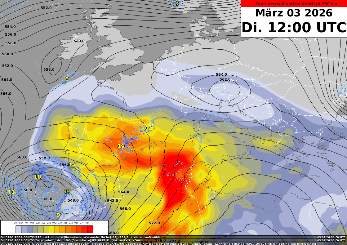
Tuesday, March 3, 12 UTC: The colored areas represent the calculated dust concentration of the special Copernicus model. The black lines show the 500 hPa isohypses of the IFS model. Source: Copernicus, ECMWF, MeteoSwiss
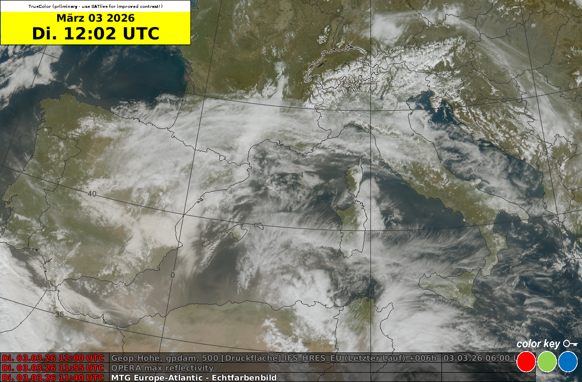
MTG satellite image from Tuesday, March 3, 12 UTC: At the beginning of the week, Saharan dust was already being carried into the western Mediterranean region. The satellite image corresponds well with the Copernicus model forecast. Source: Eumetsat
Over the course of the week, low pressure system “Regina” will move from Morocco across Spain. The stirred-up Saharan dust gradually moves closer to the Alpine region with the southwesterly flow. The measuring station on the Jungfraujoch already detected the onset of this Saharan dust event on Tuesday. On Wednesday, the sky already appears to be somewhat clouded, especially when looking towards the south. According to model calculations, dust concentrations are likely to increase, especially from Thursday onwards. However, there is still a great deal of uncertainty regarding the timing, amount of dust, and the possible impact on visibility and any clouds. Saharan dust also has various and sometimes contradictory effects on thunderstorm formation. However, these complex processes would go far beyond the scope of this article – and there are no thunderstorms in sight in the coming days anyway.
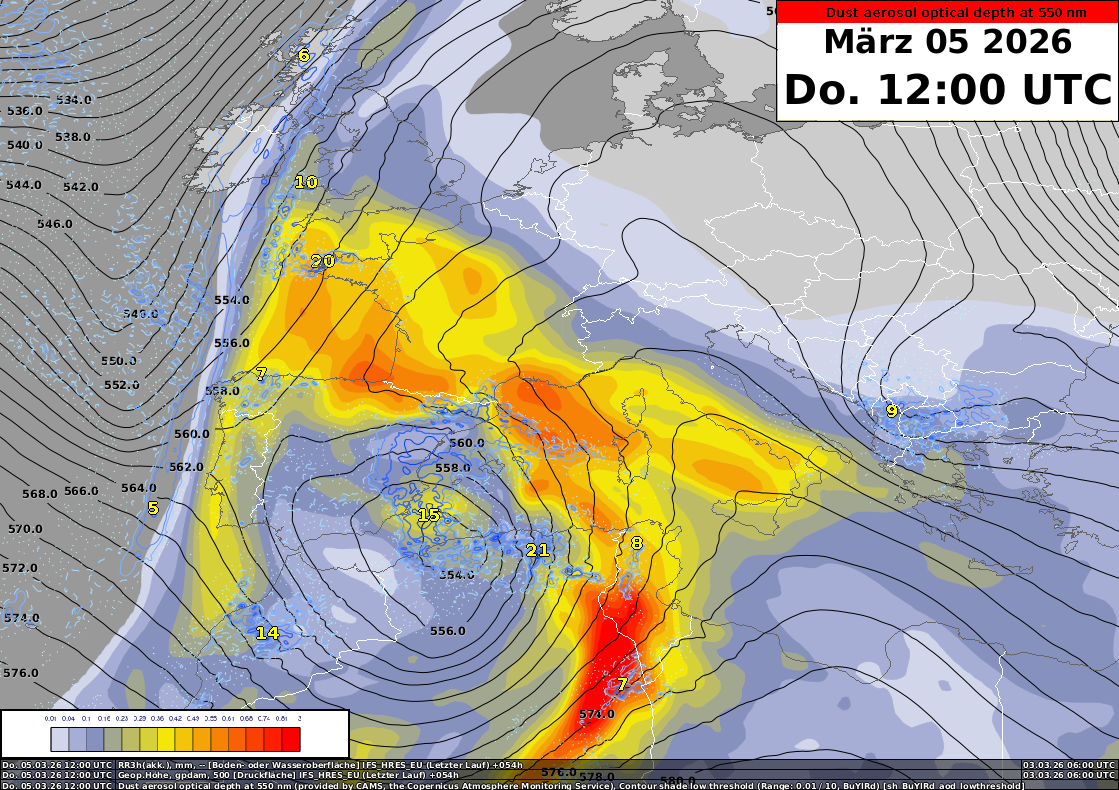
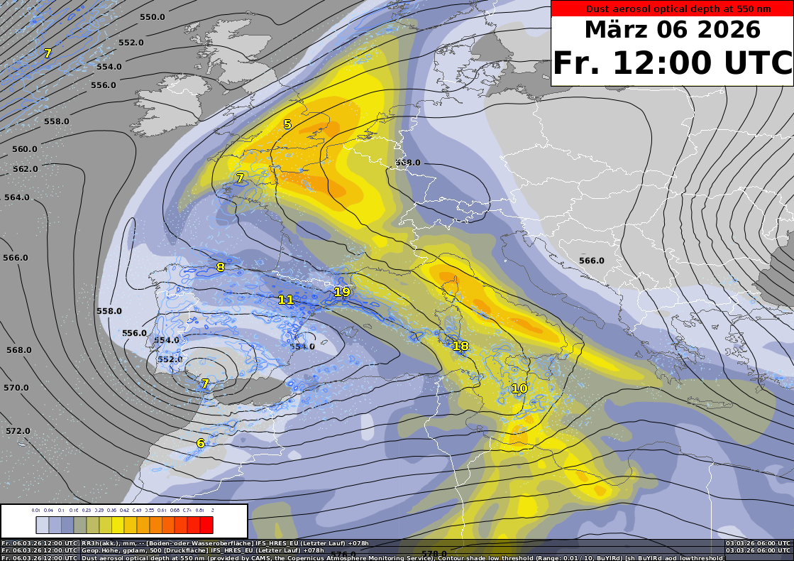
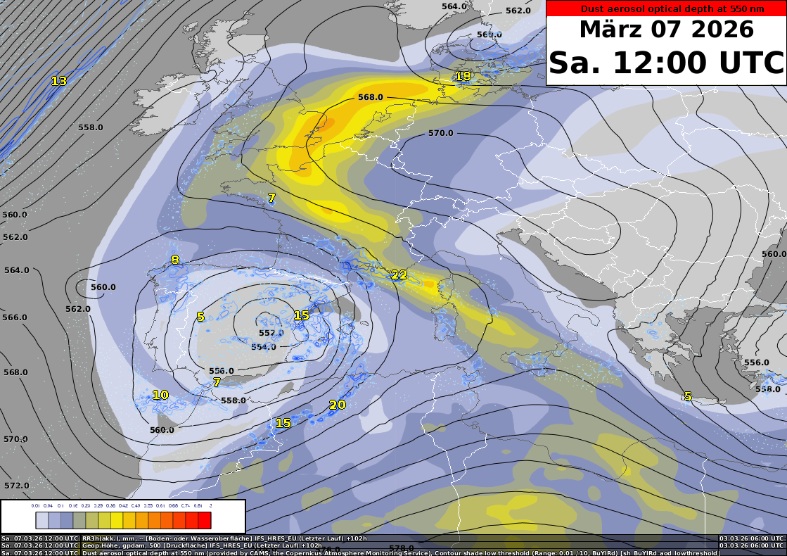
Thursday, March 5, 12 UTC, Friday, March 6, 12 UTC, and Saturday, March 7, 12 UTC: The colored areas represent the calculated dust concentration of the Copernicus model. The black lines show the isohypses at 500 hPa. Source: Copernicus, ECMWF, MeteoSchweiz
When do Saharan dust events occur most frequently?
Southern winds are needed to transport dust from North Africa to the Alpine region. Accordingly, Saharan dust events are often associated with foehn conditions. Over the course of the year, there is a maximum in spring and autumn and a minimum in summer. With this week’s weather conditions, the Saharan dust is not reaching us directly, but is being diverted around Switzerland by the high pressure system over Central Europe.
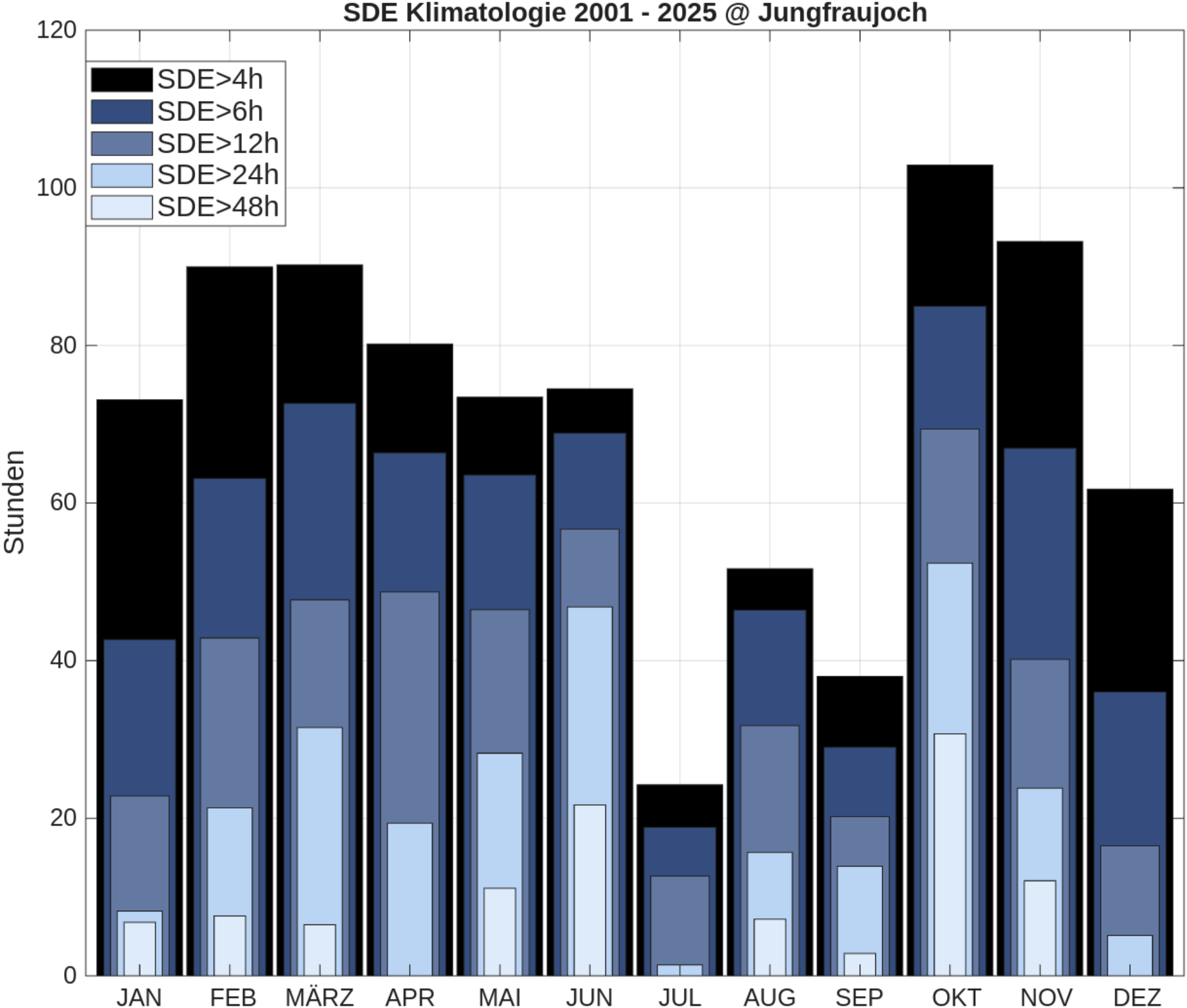
Hours with Sahara dust measured on the Jungfraujoch over the course of the year. Graphic: MeteoSwiss
How big are Sahara dust particles?
Only small and therefore light particles can remain suspended in the air for long periods of time and thus be transported over long distances. Sahara dust falls into the category of fine dust and is measured as PM10 or PM2.5. PM stands for particulate matter. PM10 and PM2.5 are particles with a diameter of less than 10 micrometers and 2.5 micrometers, respectively.
What are the effects of Saharan dust on aviation?
Compared to volcanic ash, the impact of Saharan dust in our latitudes is minor and mostly harmless to aircraft performance. Sandstorms in desert regions have more serious consequences; in addition to strong winds and massive reduction in visibility, there is a risk of loss of performance and engine damage (e.g., glazing due to molten sand) as well as structural damage (“sandblasting” of exterior surfaces and windows). In our regions, however, the Met Vis is also affected. When the sun is low, more light is scattered, which reduces Met Vis. So even for a short evening flight, it is advisable to pack your sunglasses. It should also be noted that in calm weather, dust particles can settle over the Alps at pass height and down into the valleys, where reduced visibility is particularly sensitive for VFR flights. Before the flight, visibility can be checked on webcams along the route.
Sahara dust can also affect human performance: during very severe events, there have been reports of increased fatigue and lethargy caused by the monotonous and slightly reddish sky. As with any weather condition, it is generally recommended that you only enter the cockpit when you are rested and fit. And for people with respiratory diseases in particular, the fine dust can also become a burden when the particles reach the air layers close to the ground.
If you have any questions, it is also worth calling the aviation weather center in Zurich to find out more about the event and its impact on your planned flight. We look forward to advising you personally on 0900 162 737.
Jetzt registrieren!
Um alle Funktionen zu nutzen, erstellen Sie einfach ein neues Konto. Dann können Sie Artikel für später vormerken, Themen abonnieren und regelmäßige Aktualisierungen für Ihre Themen per E-Mail erhalten.