Guest contribution from MeteoSwiss: Wintertime is inversion time

When talking about adverse weather conditions for aviation, the focus is usually on thunderstorms, turbulence, or ice. However, inversions are rarely mentioned in flight planning. Yet it is precisely this phenomenon that combines several factors that must be taken into account when planning flights during the cold season.
What is an inversion?
Basically, the temperature in the weather layer decreases with increasing altitude. However, if there is an increase in temperature in a certain layer, this is referred to as an inversion or temperature reversal. Inversions can be found at different altitudes. If the inversion begins directly above the Earth’s surface, it is referred to as a ground inversion. Inversions are characterized by stability, so that the layers of air are literally separated from each other. The lower cold layer can hardly mix with the upper warm layer. Due to this lack of mixing, water droplets and other aerosols accumulate in the lower cold layer. Above an inversion, visibility is usually excellent, whereas below it is usually reduced due to moist haze (BR), fog (FG), or dry haze (HZ).

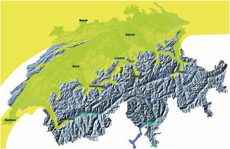
In the Swiss Plateau, an inversion layer with stratus clouds can also be lifted by the bise wind, which we know as high fog.

Lägern Hochwacht during an inversion with a view to the south.

LSZH airport in high fog. Departing aircraft “disappear” into the low base/inversion.
In what weather conditions do inversions occur?
Inversions form in high-pressure systems, and occasionally also in flat pressure distributions. In a high-pressure system, the air sinks over a large area and warms up. This sinking process, also known as subsidence, causes cold air to become “trapped” in the lower layers of the atmosphere if it cannot escape due to orographic conditions, for example. In Switzerland, inversions occur not only over the Swiss Plateau due to the boundaries formed by the Jura and Alps, but also on a smaller scale in valley basins.


Subsidence in a high-pressure area. Clearly visible in the temperature and dew point profile.
How does an inversion affect flight planning?
Performance
Since the cold air near the ground is denser than the warm air above the inversion, an aircraft climbing through the inversion may experience a noticeable loss of performance. This depends on the strength of the inversion. This effect is particularly noticeable during the climb out when flying through the inversion, especially with heavily loaded aircraft. The rapid change from cold, denser air to warm, less dense air causes a change in density altitude. It is therefore also an issue in connection with inversions!

“Climb out” LSZH from an inversion. 11/23/2023
Turbulence in the inversion zone
Since the air layer below the inversion is separated from the air layer above it, different air currents can prevail depending on the altitude. When flying through the inversion, the wind speed and direction can change abruptly. Depending on the airflow around the aircraft, there may be effects on speed and lift. An unfavorable wind effect combined with a loss of performance due to decreasing density during climb through an inversion is particularly dangerous.

Effect of an inversion on visibility
When descending through an inversion, visibility can deteriorate abruptly. This is particularly the case with an inversion that has “aged” over several days, whereby aerosols accumulate in the cold lower air layer in addition to moisture. Visibility is particularly reduced when the sun is low in the sky, as the light is strongly scattered by the aerosols, leading to glare.
In diffuse light and weather conditions and when the sun is low in the sky, the use of an iConspicuity device for traffic detection and improved situational awareness is highly recommended for VFR flights:
Technologie-Empfehlung i-Conspicuity Geräte

Icing
Inversion layers are also typically fog or high fog layers. During IFR flights, icing is therefore to be expected within high fog, caused by the contact of supercooled water droplets with the cell, depending on the ambient temperature. It is therefore advisable to fly through this stratus layer quickly.
It should also not be underestimated that during VFR flights in rising terrain, the layer below the inversion becomes increasingly narrow because the “trapped” moisture in the cold base layer cannot escape.
Icing due to freezing rain (FZRA)
With a warm front, the warm air is first noticeable at higher altitudes. A warm front is therefore a huge inversion, especially when it glides over a cold base layer. Caution is advised here: if snow melts into rain in the warm layer at higher altitudes and falls further down into icy cold air, FZRA occurs.


How is attention drawn to an inversion layer?
In the TAF/METAR for airports in the Swiss Plateau, pay attention to poor visibility and often low cloud bases. Compare TAF and METAR with higher-altitude stations.
- LSZS SAMEDAN 00000KT CAVOK M11/M12 Q1024=
- LSZH ZURICH 14003KT 9000 OVC009 06/05 Q1024 NOSIG=
Consult ATIS LSZH. If there is a strong inversion, this will be indicated with altitude information and a wind shear warning. Call 043 488 19 50 to access this information.
- INVERSION OF 14 DEG CELSIUS BTN 2000FT AND 3000FT QNH
Studying satellite images: Inversion conditions can also be easily recognized by the fact that the Swiss Plateau is filled with fog or high fog and the Alpine airports are clear.
Consult the Payerne emagram: This can be accessed on the MeteoSwiss homepage.
- https://www.meteoschweiz.admin.ch/service-und-publikationen/applikationen/radiosondierungen.html#tab=radio-soundings-emagram
- If the temperature increases with altitude, an inversion can be found there.


If you are unsure, you can also request a 24-hour telephone consultation with the aviation weather service on 0900162 737.
Graphics: K.H. Hack “Aviation Weather”
Photos: D. Buck
Jetzt registrieren!
Um alle Funktionen zu nutzen, erstellen Sie einfach ein neues Konto. Dann können Sie Artikel für später vormerken, Themen abonnieren und regelmäßige Aktualisierungen für Ihre Themen per E-Mail erhalten.


